The Toranomon 1- and 2-Chome District Type 1 Urban Redevelopment Project is a Type 1 urban redevelopment project underway in Toranomon 1-chome and 2-chome, Minato City, Tokyo. In public materials from Minato City and the Tokyo Metropolitan Government, the project is organized as a plan covering an area of approximately 2.2 ha and aimed at forming an international business and exchange hub, advancing not only upgrades to office and commercial functions but also station plazas, roads, parks, pedestrian paths, and improved disaster resilience as an integrated package.
The district is located in the northeastern part of Minato City, and Supplementary Line Street No. 2, corresponding to National Route 1, runs north-south through it. The east side is bordered by Special Ward Road No. 101, the north side by Loop Route No. 2, the west side by several special ward roads, and the south side by Special Ward Road No. 1014, placing it close to the Kasumigaseki government district and in a location that continues seamlessly with the redevelopment around Toranomon Hills. The project plan identifies the large number of older non-seismic buildings, narrow roads and undeveloped sidewalks, and a shortage of places to relax and greenery as the district's main issues.
The key point of the plan is that it will enhance transport hub functions in tandem with the development of Toranomon Hills Station on the Tokyo Metro Hibiya Line. Rather than a standalone supertall development, it should be viewed as a project that upgrades the way the surrounding blocks are used by creating a pedestrian network and plaza spaces spanning ground, underground, and deck levels, while combining office, commercial, hotel, residential, child-rearing support facilities, and a business information hub.
Project Overview
| Item | Details |
| Project name | Toranomon 1- and 2-Chome District Type 1 Urban Redevelopment Project |
| Location | Toranomon 1-chome and 2-chome, Minato City, Tokyo |
| Implementer | Toranomon 1- and 2-Chome District Urban Redevelopment Association |
| Project owner | Not disclosed in the scope of publicly available materials |
| Participating association member | Not disclosed in the scope of publicly available materials |
| Project partner | Not disclosed in the scope of publicly available materials |
| Area | Approximately 2.2 ha |
| Site area | Not disclosed in the scope of publicly available materials |
| Total floor area | Approximately 253,540 sq m (total for blocks A-1 to A-3) |
| Height | Block A-1 approx. 266 m, Block A-2 approx. 30 m, Block A-3 approx. 59 m |
| Floors | Block A-1: 49 floors above ground, 4 below; Block A-2: 4 above, 3 below; Block A-3: 12 above, 1 below |
| Main uses | Offices, shops, residences, hotel, business information hub, child-rearing support facilities, parking, etc. |
| Building scale | Block A-1 high-rise mixed-use building, Block A-2 retail building, Block A-3 low-rise mixed-use building |
| Number of housing units | Approximately 12 units |
| Urban planning decision | March 2018 |
| Approval | Association establishment approved in November 2018, rights conversion plan approved in March 2019 |
| Construction start | November 2019 |
| Scheduled completion | Construction completion scheduled for fiscal 2024 |
| Project cost | Approximately 226.8 billion yen |
Project Features
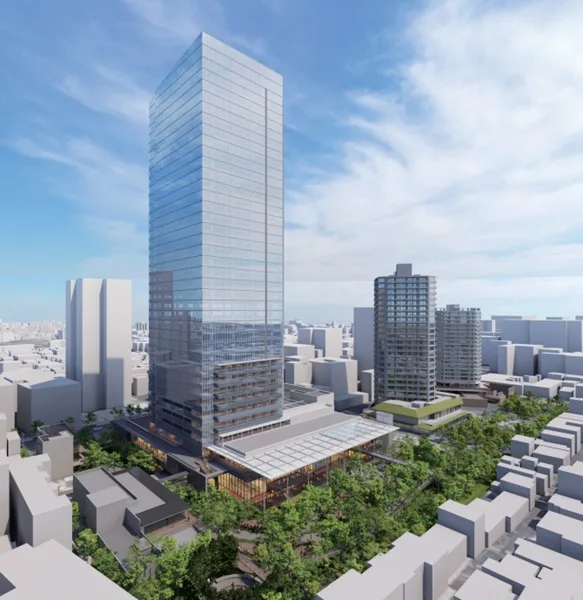
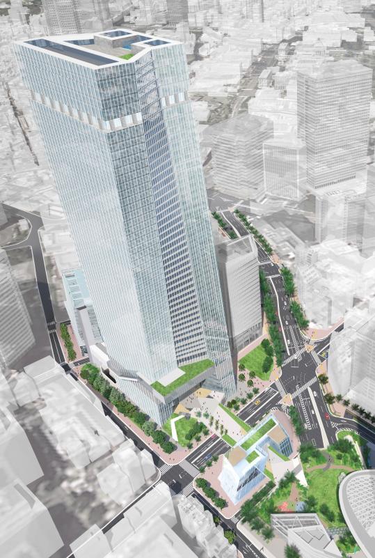
The defining feature of this plan is the three-dimensional transport and plaza development integrated with Toranomon Hills Station. In the project plan, Pedestrian Path No. 1 connecting the new station and the surrounding urban area is to be developed at deck level with a width of 4 m and a length of approximately 75 m, and Pedestrian Path No. 2 at underground level with a width of 5.5 m and a length of approximately 55 m. The station plaza connecting from the ticket gate level on basement level 2 to ground and deck levels is positioned as the east and west entrances of blocks A-1 and A-2.
Plaza development is also a core element of the project. By making use of the space above National Route 1 and above Special Ward Road No. 101, the plan creates a deck-level plaza space that is three-dimensionally continuous with the adjacent Toranomon Hills plaza; including existing parts, a cohesive space of about 1 ha is envisioned. Within the district, Plaza No. 1 of approximately 3,300 sq m and Park No. 1 of approximately 770 sq m are to be newly created, and the reorganization of pedestrian-only space is also incorporated, making this not simply a plan to build buildings, but one that simultaneously improves block permeability and staying quality.
The facility plan consists of three blocks, A-1 to A-3. Block A-1 is the core block, with a total floor area of approximately 236,640 sq m, 49 floors above ground and 4 below, and a height of approximately 266 m, housing offices, retail, a hotel, and a business information hub, among other functions. Block A-2 is a retail building with a total floor area of approximately 8,800 sq m, 4 floors above ground and 3 below, and a height of approximately 30 m, while Block A-3 is a low-rise mixed-use building with a total floor area of approximately 8,100 sq m, 12 floors above ground and 1 below, and a height of approximately 59 m, including offices, retail, residences, and child-rearing support facilities. The housing component totals about 12 units, with 1LDK, 2LDK, and 3LDK layouts indicated, and the average exclusive floor area is about 100 sq m.
The wide scope of public facility improvements is also important. The plan includes redevelopment and widening of Supplementary Line Street No. 2, District Trunk Road No. 1, and Block Roads No. 1 through 6, and the total parking supply is planned at 308 spaces. Although the publicly available materials do not show specifications for individual equipment, the project clearly serves as a redevelopment that updates the foundations of disaster response, transportation, and urban activity through an integrated approach to replacing older non-seismic buildings, improving narrow roads, and strengthening disaster resilience.
Relationship to Surrounding Projects and Area
The Toranomon 1- and 2-Chome District is located near the Kasumigaseki government district and in a highly international office area with a concentration of embassies and foreign-affiliated companies. The project plan also refers to the area's highly international character, including foreign residents, and treats it not simply as a supply of office floor space but as an update to a central Tokyo hub where international finance, business, commercial, and cultural exchange functions overlap.
In terms of connections to the surroundings, the continuity with Toranomon Hills is especially significant. The project's plaza will be three-dimensionally continuous with the existing plaza at Toranomon Hills, and the pedestrian deck will also connect to the implementation district of the Toranomon 2-Chome District Type 1 Urban Redevelopment Project. In other words, the official materials show a structure in which, with Toranomon Hills Station at the core, the Toranomon 1- and 2-Chome district, the Toranomon 2-Chome district, and nearby road and plaza improvements are linked across the entire area.
For this reason, the project has the character of a relay point that enhances circulation across the Toranomon area as a whole. Given its location facing Loop Route No. 2 and National Route 1, it is meaningful to reconnect pedestrian movement that tends to be divided by arterial roads through both underground and deck levels. Tokyo Metropolitan Government materials also organize the project as contributing to the formation of a business hub that represents Japan by accelerating area-wide connections with multiple large-scale redevelopment projects planned and under consideration in the vicinity, in coordination with the new station development.
On the other hand, the detailed floor allocation by block, individual tenants, and the names of operating entities have not been disclosed within the scope of publicly available materials. Therefore, at present it is appropriate to take as confirmed fact the positioning of this project as an approximately 2.2-hectare urban infrastructure reorganization that includes connections to Toranomon Hills Station, the Toranomon Hills plaza, and the Toranomon 2-Chome district.
INA Brief
The Toranomon 1- and 2-Chome District Type 1 Urban Redevelopment Project is a plan in which the weight of plaza, deck, and road reorganization centered on Toranomon Hills Station is greater than that of constructing a supertall mixed-use tower. Viewed together with the functional split among blocks A-1 to A-3 and the pedestrian network extending to Toranomon Hills and the Toranomon 2-Chome district, this is an undertaking that should be evaluated as an area-wide renewal rather than a block-level redevelopment.
Sources and References
- Minato City: Toranomon 1- and 2-Chome District Type 1 Urban Redevelopment Project
- Minato City: Toranomon 1- and 2-Chome District Type 1 Urban Redevelopment Project, Project Plan (Excerpt)
- Tokyo Metropolitan Government Urban Development Bureau: Toranomon 1- and 2-Chome District Type 1 Urban Redevelopment Project