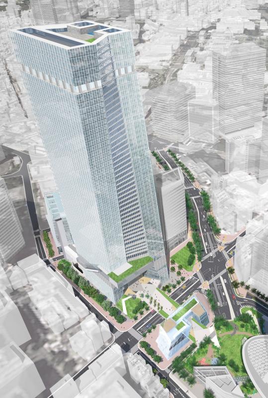
The Mita Koyamacho West District Type 1 Urban Redevelopment Project is a type 1 urban redevelopment project underway in Mita 1-chome, Minato City, Tokyo. The site is a block along Furukawa, close to Azabu-Juban, and Minato City’s published materials describe the area as one that will be comprehensively reorganized, replacing aging buildings and fragmented parcels with a plan centered on housing and supplemented by retail, living support facilities, parks, plazas, and related uses.
The project area is approximately 2.5 ha, and its defining feature is that it updates block-level issues that are difficult to resolve through individual rebuilding by integrating building development with urban infrastructure development. Rather than simply supplying housing floor area, the project can be understood as one that reorganizes how the entire block is used, including pedestrian space, disaster-response functions, waterfront circulation, and places for people to stay.
Looking at the location, the plan must balance the convenience of the Azabu-Juban area with the geographic conditions of a low-lying site along Furukawa, making the improvement of safety and ease of movement a core element. Within the scope of the publicly available materials, many individual specifications such as building height, number of floors, gross floor area, and number of units remain undisclosed, but it is clear that this is a multi-building development centered on housing and including parks and plazas as part of a mixed-use block reorganization.
Plan Overview
| Item | Details |
|---|---|
| Project name | Mita Koyamacho West District Type 1 Urban Redevelopment Project |
| Location | Mita 1-chome, Minato City, Tokyo |
| Implementer | Not disclosed within the scope of the publicly available materials |
| Project owner | Not disclosed within the scope of the publicly available materials |
| Participating association member | Not disclosed within the scope of the publicly available materials |
| Project partner | Not disclosed within the scope of the publicly available materials |
| Project area | Approx. 2.5 ha |
| Site area | Not disclosed within the scope of the publicly available materials |
| Gross floor area | Not disclosed within the scope of the publicly available materials |
| Height | Not disclosed within the scope of the publicly available materials |
| Number of floors | Not disclosed within the scope of the publicly available materials |
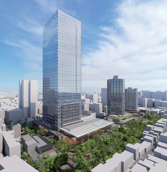
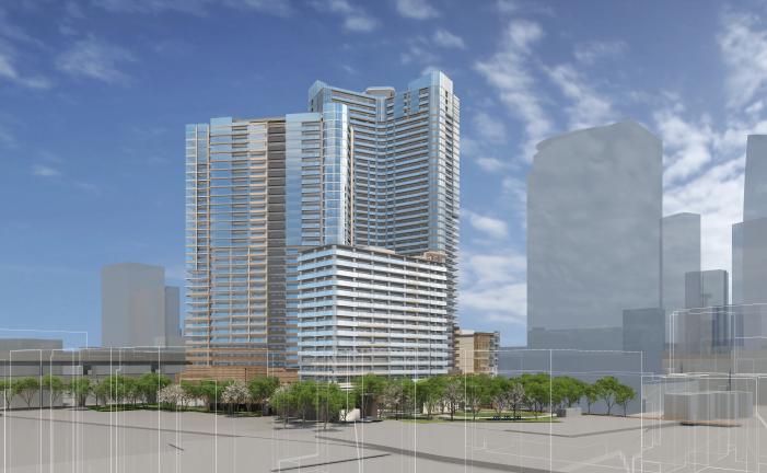
| Building scale | Large-scale housing-led redevelopment across multiple buildings |
| Main uses | Housing, retail, living support facilities, parks, plazas, etc. |
| Number of housing units | Not disclosed within the scope of the publicly available materials |
| Urban planning / progress | Developed in stages based on the project plan |
| Approval | Not disclosed within the scope of the publicly available materials |
| Start of construction | Not disclosed within the scope of the publicly available materials |
| Planned completion | Not disclosed within the scope of the publicly available materials |
| Project cost | Not disclosed within the scope of the publicly available materials |
The basic information that can be confirmed about the plan is that it is a type 1 urban redevelopment project covering approximately 2.5 ha in Mita 1-chome, and that its uses consist of housing, retail, living support facilities, parks, plazas, and related functions. Within the scope of the publicly available materials, detailed figures for floor area and unit counts remain limited, but it is clear that the project combines block reorganization with public space development.
Another important characteristic is that this is not a single-building replacement but a comprehensive area-based development involving multiple buildings. By incorporating not only housing but also retail, living support facilities, parks, and plazas into the lower floors and surrounding spaces, the plan is intended not merely as a residential concentration but as a multifaceted urban renewal project.
Features of the Plan
The defining feature of the Mita Koyamacho West District Type 1 Urban Redevelopment Project is that, while housing-led, it advances the resolution of block issues together with urban infrastructure development. The site is located on low ground along Furukawa, and the area is described as retaining aging buildings, fragmented parcels, and fine-grained internal circulation. Accordingly, the plan adopts an area-based reorganization approach that updates how the district is used, rather than relying on piecemeal rebuilding.
The use mix consists of housing, retail, living support facilities, parks, plazas, and related functions. While housing supply is the main axis, the addition of functions that support daily life within the block positions the project as a multifaceted urban renewal rather than a simple residential cluster. The specific content of the living support facilities is not disclosed within the scope of the publicly available materials, but the fact that the plan provides non-residential supporting uses is itself an element that broadens the district’s time-of-day use and circulation.
The explicit inclusion of parks and plazas also clearly reflects the character of this project. In a location along Furukawa, continuity of waterside space and the formation of routes that allow pedestrians to move safely and naturally are directly tied to the district’s value. The development of plazas and open spaces is not merely about leaving empty space; it can be read as a planning element that serves multiple roles, including evacuation space, everyday lingering, and improved connections inside and outside the block.
Improving disaster resilience is another core component of the project. Under low-lying geographic conditions, advancing building renewal and open-space development at the same time affects not only convenience in normal times but also safety during disasters. Within the scope of the publicly available materials, detailed disaster-response specifications and the names of individual facilities are not disclosed, but the project’s policy significance is evident in the way it jointly emphasizes block reorganization along Furukawa and improved disaster resilience.
Another feature is that development is expected to proceed in stages. In large-scale redevelopment, multiple components such as buildings, roads, pedestrian spaces, plazas, and parks are interrelated, so the quality of the finished outcome cannot be measured by a single building’s specifications alone. In this project as well, the key issue for the overall completion of the district will be how the housing-led multi-building development, park and plaza improvements, and waterside circulation enhancements are connected.
Relationship to Surrounding Projects and Area
In terms of location, the fact that the project is along Furukawa in Mita 1-chome, near Azabu-Juban, gives it significant meaning. While the area offers the convenience of inner-city living, it is also a low-lying waterfront district with its own issues in terms of block connectivity and pedestrian movement. For that reason, this project plays a role not just in renewing a single building but in redesigning continuity of movement across the surrounding area.
In relation to the surrounding area, it is important to see how the living sphere on the Azabu-Juban side and the blocks on the Mita 1-chome side can be connected smoothly. If streets, parks, plazas, and spaces where pedestrians can linger are improved along Furukawa, the perceived distance and circulation from the station area to the project site could change. The impact of redevelopment on the surrounding area is shaped not only by numerical indicators such as height or number of units, but also by how circulation inside and outside the block is renewed.
Minato City also continues to see multiple redevelopments and block renewals around Mita and Azabu, and this project should be viewed as part of that broader area-wide transformation. In particular, within the Mita area, there is strong importance attached to projects that improve disaster resilience, pedestrian networks, and the quality of public space in ways that are difficult to address through individual block rebuilding. This project can be understood as fulfilling that role while taking into account the spatial characteristics along Furukawa.
Within the scope of the publicly available materials, the detailed design of surrounding roads and the names of specific connection facilities have not been disclosed. However, the very idea of placing housing, retail, living support facilities, parks, and plazas together reflects a premise of relationship with the surrounding blocks. When considering the completed block image, the evaluation axis will be less about the outline of a single building and more about how much continuity along the waterfront, internal block permeability, and pedestrian-space quality can be improved.
INA Brief
The Mita Koyamacho West District Type 1 Urban Redevelopment Project is an easy case to frame as a redevelopment that addresses both the convenience of central Tokyo living near Azabu-Juban and the block-level issues of low-lying land along Furukawa. Although many items remain undisclosed, the framework is clear: approximately 2.5 ha, multiple housing-led buildings, park and plaza development, improved disaster resilience, and better waterfront circulation. When completed, the project is likely to be judged less by the scale of the buildings than by how well it integrates block connections and public space quality.
References