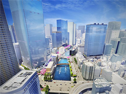
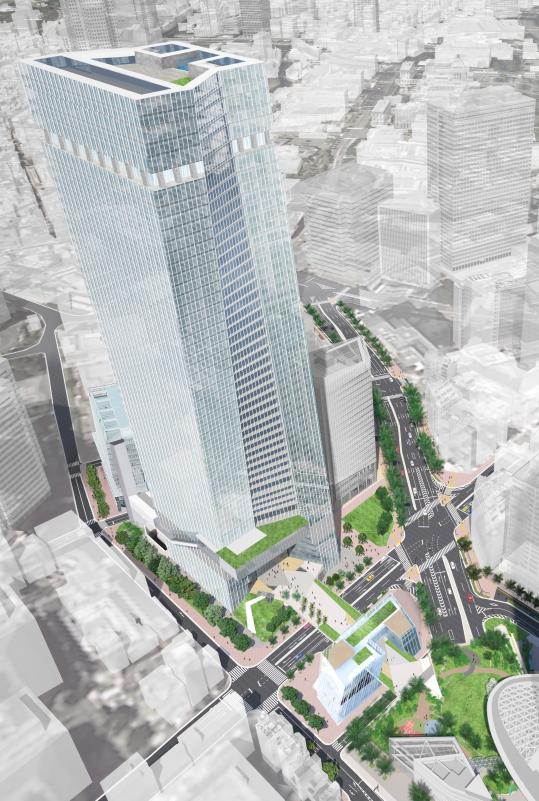
Walk out of the north exit of Nakano Station in western Tokyo and you can clearly see the flow of people heading toward Nakano Central Park (中野四季の都市, Nakano Shiki no Miyako) and Nakano Shiki no Mori Park. The Kakoi-cho East District Category 1 Urban Redevelopment Project is an area renewal of about 2.0 ha that layers housing, offices, retail and plazas along that route. For landowners and property owners, the important thing is not to stop at the news that "a large building has been completed." When walkability around the station, the working population, the time people spend at shops and disaster resilience change, the leasing terms and renovation priorities of nearby rental properties also shift. In this article, we set out the plan as confirmed in official materials and, drawing on our own on-the-ground experience, explain what to look at in real-estate practice in the Nakano area.
The project is also a clear example of a distinctly Japanese redevelopment mechanism. Under the urban redevelopment project system (市街地再開発事業, shigaichi saikaihatsu jigyō), the existing landowners form an association with developers and, rather than simply selling out, exchange their old land for floor space in the new towers. For readers from the US, the UK or Australia, where a developer usually buys a site outright and builds on it, this landowner-led structure explains why Japanese projects take many years and why so many parties share in the result.
What Is the Kakoi-cho East District Category 1 Urban Redevelopment Project?
When a property owner asks us, "How far will the redevelopment in front of Nakano Station affect my rental business?", the first thing to confirm is the project's location and role. The Kakoi-cho East District is in Nakano 4-chome, Nakano City, Tokyo, close to Nakano Station. The Tokyo Metropolitan Government Bureau of Urban Development (東京都都市整備局) explains that the district was previously crowded with detached houses and apartment buildings, with narrow roads and many dead ends, so its road infrastructure was underdeveloped.
In response, the project aims to improve road infrastructure, including the planned city road Auxiliary Route 221 (補助221号線), and to create a pedestrian network linking Nakano Station with Nakano Central Park, increasing both activity and disaster resilience. If you see it not as a stand-alone tower condominium development but as a redevelopment that changes "how people pass through" the area by linking the station, the park, business functions and housing, its impact on surrounding real estate becomes easier to see. Narrow lanes and dead-end roads in densely built neighborhoods are a long-standing issue in many parts of Tokyo, and in a country exposed to earthquakes and fire, widening them is as much a safety measure as an urban design choice.
According to a release dated April 27, 2026 from Mitsui Fudosan Residential (三井不動産レジデンシャル) and Mitsui Fudosan (三井不動産), the district, named "Park City Nakano," was completed on April 25, 2026, with the grand opening of the retail zone and the official opening of the district (街びらき, machi-biraki) scheduled for May 29, 2026. The district opened as planned on May 29, 2026. A defining feature is its composition of two residential towers, "The Tower Airs" and "The Tower Breeze," an office building, "Nakano M-SQUARE," and eight retail and dining stores on the lower floors.
Understanding the Category 1 Urban Redevelopment Project Method
The name "Category 1 Urban Redevelopment Project" (第一種市街地再開発事業, daiisshu shigaichi saikaihatsu jigyō) is not just a label for a large development. It refers to a specific type of procedure under Japan's Urban Renewal Act (都市再開発法, Toshi Saikaihatsu Hō). When handling valuations or consultations in the surrounding area, understanding this mechanism lets you explain things much more precisely to landowners and prospective buyers.
The idea of the rights conversion method
As a rule, a Category 1 Urban Redevelopment Project proceeds by the rights conversion method (権利変換, kenri henkan). The holders of rights to existing land and buildings replace those rights with floor space in the new building, known as "rights floor" (権利床, kenri-yuka). It differs from an ordinary sale or an equivalent exchange in that owners do not give up their land for cash but transfer its value into unit ownership in the new building and a co-ownership share in the site. In the Kakoi-cho East District, the rights conversion plan was approved in February 2022. Compared with compulsory purchase or negotiated buy-outs common in Western redevelopment, this method lets many small owners remain part of the project.
Under this method, rights holders can also choose to move out (an option to leave the project in exchange for a monetary payment). Owning land within the redevelopment area does not "automatically mean acquiring a new home"; whether to stay or move out is a decision for each rights holder. When dealing with nearby properties that involve old leased land or land under leasehold, discussions go more smoothly if the existence of this option is taken as a given. Japan's distinctive system of land leasehold rights (借地, shakuchi) and the underlying land owned by someone else (底地, sokochi) often makes these conversations more complex than they would be in a freehold market.
Reserved floor space and project economics
In a redevelopment, in addition to the rights floor allocated to rights holders, "reserved floor space" (保留床, horyū-yuka) is created for the project operator to sell or lease. In this case, much of the housing for sale and the offices and stores for lease fall into this category. Because income from selling and leasing reserved floor space funds the project costs, operators have an incentive to raise the marketability of the location. The participation of the Mitsui Fudosan group as participating association members is a factor that may also influence surrounding market prices, in terms of its ability to turn reserved floor space into products and its brand appeal. However, as discussed again later, being nearby does not automatically raise value.
Plan Overview: The Scale of the District in Numbers
When marketing rentals or valuing properties for sale near the site, the phrase "large-scale redevelopment in front of the station" is not enough. Pinning down the scale, uses and schedule in numbers provides material that can be used in explanations to clients and investment decisions. The following summarizes what can be confirmed in official materials.
| Item | Details |
|---|---|
| Project name | Kakoi-cho East District Category 1 Urban Redevelopment Project (囲町東地区第一種市街地再開発事業) |
| District name | Park City Nakano |
| Location | Nakano 4-chome, Nakano City, Tokyo |
| Implementing body | Kakoi-cho East District Urban Redevelopment Association |
| Participating association members | Mitsui Fudosan Residential Co., Ltd., Mitsui Fudosan Co., Ltd. |
| District area | About 2.0 ha |
| Project cost | About ¥71.1 billion (approx. USD 459 million) |
| Total floor area of facility buildings | About 120,545 m² |
| Main uses | Housing, business, retail, bicycle parking, car parking, etc. |
| Number of homes | About 807 |
| Retail | Eight retail and dining stores on the lower floors |
| Office | Nakano M-SQUARE. The release describes a floor plate of about 1,300 m² and full occupancy at completion |
| Number of floors and height | Not published on the Tokyo Metropolitan Government page. Need to be checked individually in the project plan and other documents |
| Main milestones | City planning decision in December 2015, approval of association establishment in September 2020, approval of the rights conversion plan in February 2022, start of building construction in September 2022 |
| Completion and district opening | Completed on April 25, 2026; district opened on May 29, 2026 |
Currency conversions in this article use an approximate rate as of October 2026 of 1 USD ≈ 155 JPY and are for reference only.
What deserves attention is that this is a mixed-use project including not only about 807 homes but also business, retail, bicycle parking and car parking. The area around Nakano Station already has diverse demand from single people, dual-income households, creative industries and people connected with universities. Adding offices and stores changes the weekday daytime population and how long people stay in the evening, which also affects the conditions under which nearby restaurants, services and small shops can succeed. The scale of the project cost also shows that this is a development to be read in terms of its wider spillover, not as a single block.
What Changes Through Public Facilities and Urban Infrastructure?
When assessing the practical impact of a redevelopment, we check roads and pedestrian routes before the brand name of the buildings. The Kakoi-cho East District is a project that not only intensifies land use in front of the station but also improves the infrastructure of a district that had many narrow and dead-end roads. Matching each improvement with how to read it in real-estate practice gives the following.
| Item | What can be confirmed | How to read it in real-estate practice |
|---|---|---|
| Roads | Construction of planned city road Auxiliary Route 221 (16 m wide) and District Road No. 1 (14 m wide) | Visibility for vehicles and pedestrians improves, providing material to explain daily convenience and disaster resilience |
| Pedestrian network | Plan to improve walkability linking Nakano Station and Nakano Central Park | There is room to show in marketing materials not only distance from the station but whether the route is actually easy to walk |
| Pedestrian deck | According to the Mitsui Fudosan release, a pedestrian deck connection to JR Nakano Station is scheduled for fiscal 2029 | Because the flow of people changes before and after completion, think separately about when to review ground-floor stores and surrounding rents |
| Plazas and green space | A green landscape connected to Shiki no Mori Park and an "Omatsuri Plaza" (festival plaza) are being created | Makes it possible to promote the area not just as "near the station" but in terms of dwell time and event use |
| Disaster preparedness | Improvement of road infrastructure and creation of a highly disaster-resilient urban area are stated as objectives | For old wooden or small properties, explaining seismic performance, evacuation routes and common-area lighting becomes more important |
| Bicycle and car parking | Main uses include bicycle parking and car parking | In Nakano, where many people cycle, improving bicycle parking can easily become a point of differentiation for nearby properties too |
Note in particular that the pedestrian deck will not be fully completed at the time of building completion. The new district starts operating with its opening in 2026, but the deck connection to Nakano Station is scheduled for fiscal 2029 (Japan's fiscal year runs from April to March, so this means April 2029 to March 2030). For investment decisions, it is therefore important to separate "expectations immediately after opening" from "walkability after the deck connection." Planning the timing of leasing and sales on the assumption that pedestrian flows will change in two stages over several years reduces uncertainty.
Seeing It as Part of the Renewal of the Nakano Station Area
When showing people around the site, it is more effective to explain the change in the Nakano Station area as a whole than to single out the Kakoi-cho East District. To the north of the district are Nakano Central Park and Nakano Shiki no Mori Park, and large-scale land-use renewal continues on the north exit side of the station. Within that flow, the Kakoi-cho East District is the block that receives pedestrian movement on the east side, from the station toward Nakano Central Park.
The Tokyo Metropolitan Government's explanation also includes forming a pedestrian network linking Nakano Station and Nakano Central Park among its aims. The Mitsui Fudosan release states that, after about 20 years of work, the area has been reborn as "Park City Nakano," and that it creates an extensive green space connected to the greenery of Shiki no Mori Park. In other words, this is not a development that is complete within the shared facilities of its own buildings, but one that connects with the public space and park in front of the station.
In Nakano, subculture, universities, offices and housing are mixed at close range. As office workers, visitors and event participants increase, not just the residents of the new condominium towers, it becomes easier for nearby small rental properties and stores to present the area as "a town where you can spend your time on foot." On the other hand, less competitive properties will have their outdated equipment and common areas compared more starkly than before. A rise in the surrounding market does not necessarily translate into a tailwind for existing properties; it is more realistic to expect it to come with polarization. Many international visitors know Nakano mainly for Nakano Broadway and its anime and collectibles shops, but for investors the more relevant story is its steady rental demand from commuters and students along the JR Chuo Line.
Three Practical Points Landowners and Owners Should Check
Focusing only on "Will land prices rise because of the redevelopment?" leads to rough judgments. In practice, nearby owners should check three areas separately: leasing, renovation and exit. Below we spell out what to look at in each.
1. Leasing terms: explain everyday routes, not just station proximity
For properties within walking distance of Nakano Station, many competitors already emphasize distance from the station. From now on, it will be important to show concretely how residents walk in everyday life, including proximity to Shiki no Mori Park, the lower-floor stores, the plazas and the offices. For single occupants, for example, you can explain the stores they can use on the way home and the open feel on the park side. For families, you can add information on green space, pedestrian routes and disaster resilience. Not ending leasing floor plans and descriptions with just the distance from the station is what will make the difference from now on. Japanese listings almost always state walking minutes to the nearest station, so going beyond that number is a simple but effective way to stand out.
2. Renovation priorities: do not leave common areas and bicycle parking until last
Once the lower floors and exterior of the new district are complete, differences in the impression of entrances, lighting, notice boards, garbage areas and bicycle parking tend to stand out in older nearby buildings. Improving the common areas that people see first, not just renovating interiors, translates directly into leasing power. Nakano in particular has many cyclists, so organizing bicycle spaces and improving roofs, racks and routes is an area where relatively small investments tend to have an effect. When setting priorities, the standard approach is to start with the places a prospective tenant sees in the first ten seconds.
3. Exit strategy: think about 2026 and fiscal 2029 separately
After the district opens there will be buzz, but another stage of change in walkability is expected in the run-up to fiscal 2029, when the pedestrian deck connection is scheduled. If you are considering a sale, your decision will differ depending on whether you act on short-term news value or wait for valuations after the deck connection. If you continue to hold, it is a good idea to plan to improve common areas, exteriors and rent levels in stages by fiscal 2029. The table below shows an example of points to consider when thinking in two stages.
| Timing | Main changes | What owners should focus on |
|---|---|---|
| 2026 (around the district opening) | Buzz and more visitors from completion, the retail grand opening and residents moving in | Refresh leasing copy, improve the first impression of common areas, add nearby stores to selling points |
| Fiscal 2029 (deck connection scheduled) | A further change in walkability from the pedestrian deck connection to Nakano Station | Recheck rent levels, reconsider whether to sell or hold, reconfirm changes in pedestrian routes |
INA's View: Look at "Operations After Completion" in Redevelopment
We do not evaluate a redevelopment only at the point when the buildings are completed. We look at how people walk once the district is in place, where they stay and which stores are used every day. In the Kakoi-cho East District, about 807 homes, offices said to be fully occupied at completion, eight lower-floor stores, plazas, green space and a future deck connection all come together. For surrounding real estate, this means not only "more points of comparison" but also "more lifestyle value that can be explained."
However, because we value trust and honesty, we also state the downsides frankly. Simply being near a redevelopment does not automatically raise a property's valuation. Tenants look at the walk home from the station, how bright it is at night, how clean the entrance is, how easy it is to park a bicycle, and how convenient parcel delivery and garbage disposal are. The more a large development raises the standard of the surrounding area, the more the management quality of existing properties is compared by the same standard. Uplift in the surrounding area becomes a tailwind for properties that have been improved and a headwind for those that have been neglected.
In the end, what supports this kind of steady day-to-day management is the people who deal with properties and tenants on the ground. We regard our staff as human capital (人財, jinzai, a Japanese term that writes "people" with the character for "wealth") and our greatest asset, because it is people who can translate a major environmental change such as a redevelopment into daily management quality. Reading changes in the area with a long-term view and building up management that satisfies both owners and tenants is, in the end, the most reliable way to protect assets.
On the same redevelopment theme, our articles on the Kobe Sannomiya Kumoidori 5-chome District Category 1 Urban Redevelopment Project and on the plan overview of the Toranomon 1-chome and 2-chome District Category 1 Urban Redevelopment Project also discuss the relationship between transport hubs and practical work in the surrounding area. Please also see our explanation of the Uomachi 3-chome Block 2 District Category 1 Urban Redevelopment Project and the list of real estate network articles on the category top page. In Nakano, it is important to read the flow of people in front of the station and the proximity of parks, housing and business from the perspective of the people who live there.
Summary: What to Check in the Kakoi-cho East District
- The Kakoi-cho East District Category 1 Urban Redevelopment Project is a mixed-use redevelopment renewing about 2.0 ha near the north exit of Nakano Station.
- A Category 1 Urban Redevelopment Project in principle uses the rights conversion method, and understanding the structure of rights floor and reserved floor space makes its impact easier to read.
- It includes about 807 homes, offices, eight lower-floor stores, bicycle parking and car parking, so it is not simply a housing development.
- Key points are planned city road Auxiliary Route 221, District Road No. 1, the pedestrian network and improved disaster resilience.
- It was completed on April 25, 2026, and the district opened on May 29, 2026. The pedestrian deck connection to Nakano Station is scheduled for fiscal 2029.
- Nearby owners should think about leasing terms, common-area renovations and exit strategy in two stages: "2026" and "fiscal 2029."
Frequently Asked Questions
Q1. Where is the Kakoi-cho East District Category 1 Urban Redevelopment Project located?
A. It is in Nakano 4-chome, Nakano City, Tokyo. It is close to the north exit of Nakano Station, in a location where its connection with Nakano Central Park and Nakano Shiki no Mori Park is important. It is easiest to understand as the block that receives pedestrian movement on the east side, from the station toward Nakano Central Park.
Q2. Is it a housing-only redevelopment?
A. No, it is not only housing. Tokyo Metropolitan Government materials list the main uses as housing, business, retail, bicycle parking, car parking and so on. The Mitsui Fudosan release states that it consists of two residential towers, the office building "Nakano M-SQUARE" and eight retail and dining stores on the lower floors.
Q3. When will the impact on nearby rentals appear?
A. Changes in buzz and visitor numbers are likely to appear after the district opens in 2026. In addition, because the pedestrian deck connection to Nakano Station is scheduled for fiscal 2029, pedestrian flows need to be rechecked around that time. In practice, it makes sense to look at it in two stages: short term and medium term.
Q4. Where should nearby owners start?
A. First, check the pedestrian routes on site and understand along which route your property will be seen. Then we recommend inspecting the common areas that shape impressions before a viewing, such as the entrance, lighting, bicycle parking and garbage area. Revising your leasing copy to describe everyday routes, not just distance from the station, is also effective.
References
- Tokyo Metropolitan Government Bureau of Urban Development (東京都都市整備局), "Kakoi-cho East District Category 1 Urban Redevelopment Project" (囲町東地区第一種市街地再開発事業)
- Nakano City (中野区), "About Urban Development in the Kakoi-cho District" (囲町地区のまちづくりについて)
- Mitsui Fudosan Residential (三井不動産レジデンシャル) and Mitsui Fudosan (三井不動産), "Park City Nakano completed, district opening on Friday, May 29, 2026"